
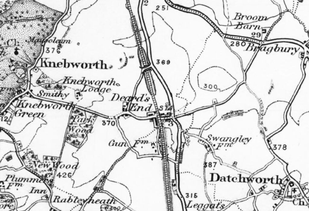
So here is the village of Knebworth in the 1890s. The first thing I notice about the north-south-east-west routes through the village is that they are exactly the same ones that we still use in the 2020s. There is the central crossroads of the old Great North Road intersecting with Station Road & Watton Road (then also Station Road); there is Deard’s End Lane, for those going from the west to the north (or vice versa); there is Gipsy Lane & Gun Lane, for those going from the west to the south (or vice versa); and of course there is Swangleys Lane to go to Datchworth.
When, a few years later, Sir Edwin Lutyens designed Knebworth Garden Village, he saw that these medieval lanes would not be sufficient for Edwardian traffic, or for the new village he planned. So he designed new broad tree-lined roads to ease the traffic flowing north-south-east-west. He planned new routes to take traffic off Deard’s End Lane, off Gipsy Lane, off Gun Lane, off Swangley’s Lane. He even planned a new tunnel under the railway just south of current cemetery, where there was an old cow tunnel. Lutyens’ Knebworth Garden Village started to be built, and became the basis of our modern village. But when it was halted by the War the infrastructure Lutyens planned was not built. So today we make do with exactly the same crossroads, and exactly the same medieval lanes, to get about our modern village.
At the time of this map, Knebworth was a few dozen houses. By 2031, it is due to be around 2,600 houses. Whether or not we agree that Knebworth should have new homes, the evidence of many public consultations is that we do agree – with Lutyens – that its Victorian rural road infrastructure has long been insufficient. New development does give us the opportunity to do something about this. Lutyens’ masterplans have been revisited and new ideas for taking traffic off our medieval lanes, and away from our central crossroads, are part of new proposals.
But we face – literally – a road block. A policy called LTP4, Hertfordshire’s Local Transport Plan, does not accept that new road infrastructure is the solution. LTP4 has the good intent of reducing car use, and creating ‘low traffic neighbourhoods’. But it seeks to do this not by giving vehicles any alternatives to our medieval lanes. It seeks to do it by closing down roads, blocking up routes, and denying new road and junction infrastructure. LTP4 wants to “reduce the ease and convenience of car use” (LTP4 p.30). There are buses for you to take, or you should cycle or walk. Rain or shine. June or January.
So, car-route-wise, Knebworth faces a future that is even more basic than this Victorian map. The one single vehicle route that we – our local rural neighbours, our buses, our delivery vans & lorries, our emergency services, anybody needing to use a car – will have to access our 2,600 homes, or the communities around them, will be via Knebworth’s central crossroads. Lutyens would be mystified.
Henry Lytton Cobbold
@HenryCobboldKH